From Satellite to Soil: Validating FieldNET Advisor with Soil Moisture Probes
Lindsay Corporation: Justin Gibson, Mitch Maguire, Martin Saylor, Tim Purswell, Quinn Charling, Bruno Keip, Rodrigo Bernardi, Tanner Oliphant, Michael Harward, Chuck Powell, Steve Risley
Introduction:
Water is one of the most valuable inputs in agriculture and one of the most complex to manage. With increasing pressure on water resources and rising input costs, growers are looking for smarter ways to irrigate. That’s where FieldNET Advisor™ comes in. It is a digital irrigation management tool that uses satellite imagery, weather data, and crop models to help growers decide when, where, and how much to irrigate. FieldNET Advisor monitors crop status and water use across all FieldNET™-connected fields in an operation and provides clear, easy-to-use recommendations that support more efficient and informed irrigation decisions.
Irrigation recommendations and soil moisture predictions are only as good as the data and science behind them. That’s why we field-test our software to ensure FieldNET Advisor performs reliably across different crops, soil types, and geographies. To do this validation we install soil moisture sensors connected to METOS by Pessl Instruments data loggers and weather stations in fields with FieldNET Advisor. Over the past three years, we’ve conducted this validation work in more than 50 fields, installing soil moisture sensors connected to METOS data loggers and weather stations in fields using FieldNET Advisor. We then compare the measurements from the soil moisture sensor to the predictions from FieldNET Advisor. For growers, this validation work builds trust in the irrigation recommendations provided by FieldNET Advisor. Whether sensors are installed in the field or not, the tool delivers insights that are grounded in real-world measurements and refined through ongoing testing.
This blog will walk through how we’re validating our irrigation recommendations, what tools and data we’re using, and why it matters for growers. By showing how we measure soil moisture and crop water use in real-world conditions, we aim to give you a clear picture of how the tool is being tested and how it’s evolving to better support your decisions in the field.
From Prediction to Proof: Validating with Sensors
To ensure our irrigation recommendations are accurate and reliable, we’ve developed a hands-on validation process that compares field-level measurements to predictive modeling. At the heart of this approach is a simple but powerful setup: we install soil moisture sensors in growers’ fields and connect them to a METOS base station. This setup allows us to continuously monitor both environmental conditions and soil moisture levels in real time.
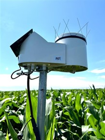
METOS soil moisture sensor base station with an optional rain bucket attached.
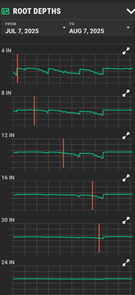
Once the soil moisture sensor is installed, we begin collecting data. The raw soil moisture sensor readings can be challenging to interpret, as the sensor measures nearby soil moisture by volume, which doesn’t directly align with irrigation scheduling needs. Instead, we convert these readings to depletion relative to field capacity. On FieldNET, users can convert raw volumetric water content (VWC, in %) to inches of soil moisture depleted by selecting readings on the soil moisture graph following a significant rainfall event. They can also identify the depth of the current root zone by reviewing the Root Depths graph and selecting the point where they first observe a daily repeating pattern of soil moisture depletion.
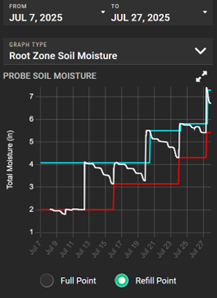
Screenshots from FieldNET where a user can tap on their active root zone, and on their full and refill points for their soil moisture sensor.
These readings can then be compared to the soil moisture predictions generated by FieldNET Advisor. By analyzing how closely the tool’s predictions align with actual field measurements, we can assess the accuracy of the model and identify opportunities to fine-tune it for specific crops, soil types, and growing conditions. This is a current snapshot on how the model is performing in a corn, potato, and peanut field:
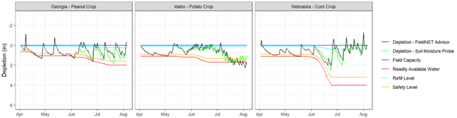
This graph shows the readings of soil moisture depletion from the soil moisture sensor (green line) and the predictions of soil moisture depletion from FieldNET Advisor (black line). The additional lines indicate field capacity, refill level (less than field capacity to leave room for unexpected rainfall), safety buffer (when to turn the pivot on), and readily available water (where stress begins).
This validation process is being carried out across a range of geographies, crop types, and weather years (50+ trials) helping us understand how the tool performs under different irrigation practices and climate scenarios. It’s a critical step in making sure our recommendations are not just theoretically sound, but practically useful for growers making decisions in the field. After 3 years of validation, we’re finding that the difference between the probe’s measured soil moisture depletion and the depletion from FieldNET Advisor is on average 0.41”, which means that even without using sensors in the field, we can predict soil moisture to be within less than a half inch of what a soil moisture probe would measure.
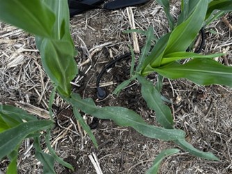
Close up of soil moisture sensor installed in the row of a corn crop.
How FieldNET Advisor Works: Remote Sensing Meets Real-Time Recommendations
FieldNET Advisor is built to make irrigation decisions easier, smarter, and more scalable, especially across large operations. At its core, the system uses satellite imagery to monitor crop health and estimate water use, eliminating the need for in-field sensors in every field.
High-resolution satellite images are processed to generate vegetation indices like NDVI (Normalized Difference Vegetation Index), which help assess plant vigor and identify variability within a field. These insights can reveal areas under stress, whether from water, nutrients, or other factors. This gives growers a clearer picture of what’s happening across their operation.
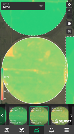
Example of satellite imagery included in a FieldNET Advisor subscription that a grower can review on their mobile device or desktop browser.
What makes the updated version of FieldNET Advisor especially powerful is its ability to estimate actual evapotranspiration (ET) using satellite-based models. ET is a key measure of how much water crops are using, and by calculating it remotely, we can provide accurate irrigation recommendations even in fields without soil moisture sensors. This is particularly valuable for large or remote operations where installing sensors everywhere isn’t practical.
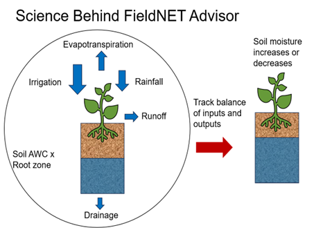
Similar to tracking the balance in a checking account, we track how much soil moisture is available in the soil by tracking how much water is leaving and being added.
The platform combines this ET data with localized weather forecasts to generate daily irrigation recommendations, telling growers when to irrigate, how much water to apply, and where it’s needed most. And thanks to recent updates, enrolling an entire operation in FieldNET Advisor now takes less than 30 seconds. With just a few clicks, growers can activate recommendations across all their connected pivots, making it easier than ever to scale precision irrigation.
This remote sensing approach not only supports smarter irrigation decisions, but it also strengthens our validation efforts. By comparing satellite-based ET estimates with on-the-ground soil moisture data, we can continuously refine the model and ensure it stays accurate across different crops, climates, and management styles.
What This Means for Growers:
By combining satellite imagery, weather data, and soil moisture comparisons, FieldNET Advisor offers a practical and reliable way to manage water use. The system is designed to be easy to use. With just a few clicks, growers can activate recommendations across their entire operation. This leads to better irrigation decisions, improved crop performance, and more efficient use of water, without adding complexity to daily operations.
FieldNET Advisor serves as a foundational layer for irrigation decision-making, providing reliable recommendations even without in-field hardware. For growers who choose to add soil moisture sensors or other technologies, the system integrates seamlessly, enhancing precision and offering deeper insights while maintaining ease of use across the entire operation. If you’d like to participate in our field trial efforts, contact your local FieldNET / Zimmatic dealer or email justin.gibson@lindsay.com.